
Southeast Alaska contains the second most shipwrecks of any area of the state. For the purposes of this site it includes everything north of the Canadian Border in Dixon Entrance all the way NW to the northern entrance of Cape Spencer. I use NOAA Chart 16016 as the primary charting tool. The locations of each wreck, given in longitude and latitude, are of the geographic feature nearest the loss, not of the wrecks themselves. I will leave that to those who visit the actual areas and seek out evidence of the casualties. I am posting the vessel names alphabetically and putting the links here as I have completed the first listings of each letter. There is an opportunity to comment at the end of each.
( A ) ( B ) ( C ) ( D ) ( E ) ( F ) ( G ) ( H ) ( I ) ( J ) ( K ) ( L ) ( M )
( N ) ( O ) ( P ) ( Q ) ( R ) ( S ) ( T ) ( U-V-W ) ( X-Y-Z )
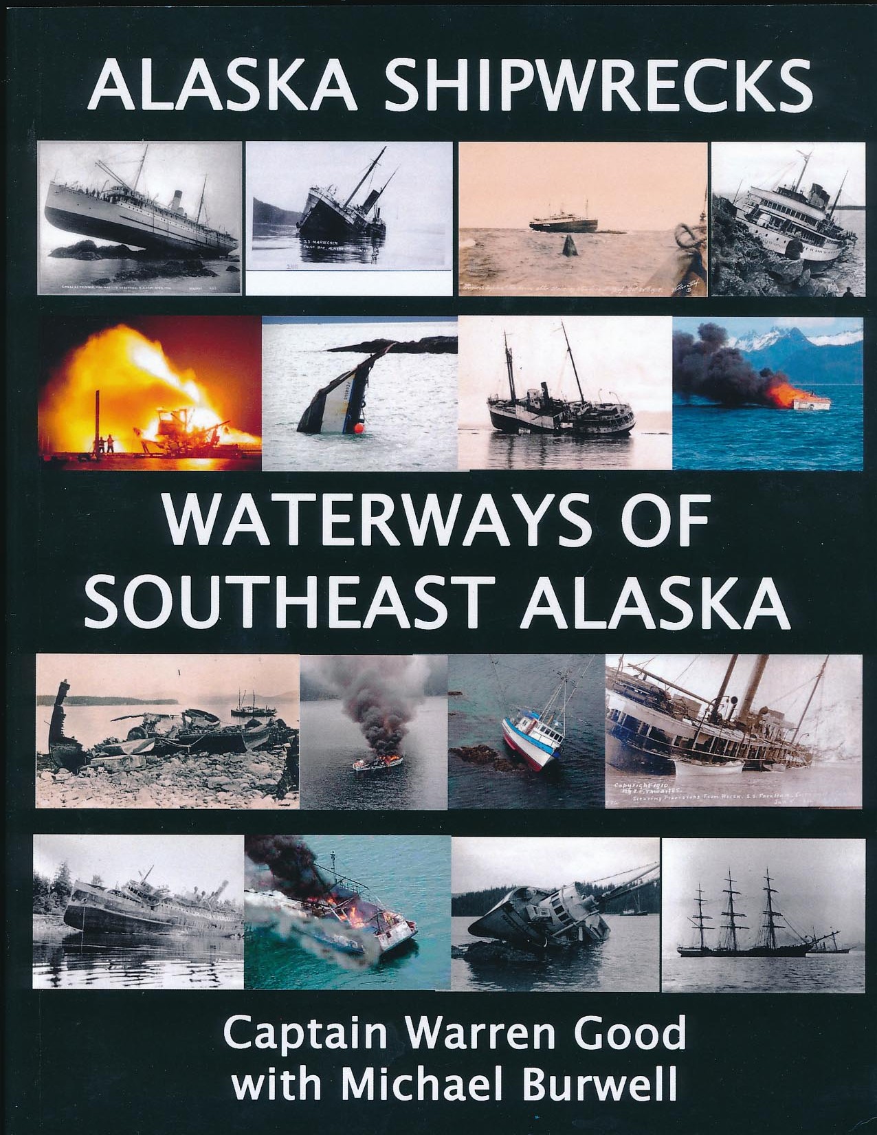
The “Alaska Shipwrecks – Waterways of Southeast Alaska” book is a comprehensive accounting of all known vessel losses in Southeast Alaska. The wrecks are presented in a geographical format, allowing the reader to locate, identify, or research each wreck by the waterways where they happened. The book is divided into three sections: Ketchikan Area, Sitka-Petersburg Area and Juneau Area. From beachcomber to marine historian, this book contains a wealth of information for anyone in Alaska or interested in her history. Click on the link to preview Waterways of Southeast Alaska and check pricing on Amazon. If you purchase the book or any other items, a commission is generated, at no cost to you, that will help maintain this valuable Alaska Shipwreck website.
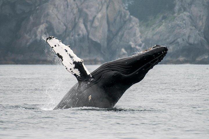
If you plan on visiting Southeast Alaska and are looking for an excursion out of Juneau, whale watching has always been a favorite of visitors and locals alike. One that has the highest possible ratings of people that have been fortunate enough to experience is Juneau Wildlife Whale Watching. Click the image for more information:
this is a great resource thanks for all your work how long did this data base take to build?
I have been working on it since the 1980’s. It is only partially complete at this point. I have a long way to go with just the basic set up. The internet is generating new information from old newspapers and family histories coming online which compounds the work. This site will never be complete by the true sense of the word as shipwrecks will continue to happen. Thanks for asking..Warren Good
Wow, you are putting a lot of work into this. Thank you; it’s really a public service. I will be checking back and browsing around a lot more.
Any wrecks in/near Grindall Bay located at the so. end of the Kassan Penninsula, Prince of Wales Is. NW of Ketchikan?
My maps are incomplete, but I have identified a few wrecks in that vicinity. They are : the scow Skip lost in 1906 off the mine at Mount Andrew, the sloop Nymph lost off the settlement of Hadley in Lyman Anchorage, the Freyea lost in 1918 near the Hadley Settlement, the Francis R lost in 1920 off Lyman Point, the fishing vessel Vis lost in 1925 off of Kasaan Island, the fishing vessel Laura lost in 1930 off of Grindall Point and the cannery tender Alaska Chief lost off of Grindall Island in 1938. Four crewmen were lost with the Alaska Chief. There are several more wrecks up in Kasaan Bay.
How many of these wrecks have been seen by divers and actually found?
Shipwrecks that are shallow enough to be seen by divers are generally salvaged. That is if the cost of salvage does not exceed the value of the lost vessel. Most wrecks are in areas that are inaccessible to divers and inhospitable to salvage efforts. Many wrecks are never located because there were no survivors to tell where the disaster took place. Also the hostile marine environment of Alaska can destroy any evidence of a wreck in just a few years. A search of “found Alaska Shipwrecks” on the internet will give you some of the many wrecks that survived the test of time and have been located. Another productive search would be “Alaska Marine Archaeology”.
Hi Scott. This is Scott Hansen from Alaska Diving Service back in the 80’s.
I saw as many wrecks as I could and raised many. What a memory it is! Hope everything is good with you.
we found what appears to be a catch anchor that looks really old……it is around 6′ high and quite heavy..not sure if there is any value to a find like this…I can give the location or if there is a way to find out where it might have come from..any info would be appreciated….
The best people to contact for such a find would be the Alaska State Office of History and Archaeology if the find is along Alaska’s coast. If at all possible it is important to get an exact orientation of the anchor before it is disturbed. An anchor left behind is often the beginning of a shipwreck and the orientation is an indicator of the wind direction and the direction the vessel in distress has taken when the anchor broke free. You could compare the lay of the anchor to skid marks in an auto accident. If you remove the skid marks you may have made it more difficult to find a missing wreck. Of course only a small percentage of lost anchors have associated ship wrecks. I have thousands of accidents recorded where vessels lost anchors, piled up on the rocks and then re-floated themselves and moved on. I can do a location specific search for you if you would like, to see if there were any missing vessels in the area or anchor loss incidents in my records.
I sunk trapped inside the F/V Myrtle D in Cross Sound in 1997, yes I went to the bottom of the ocean before I got out. The bow stem and about ten planks and foredeck washed up on George Island although I did not find it until ten years later. And are still there.
In the entrance of Deer Harbor there is a very old shipwreck that has always interested me as I was told (compleatly unconfermid) that the obstruction making entry to Deer Harbor difficult is the large steam engine from that wreck. I wonder if anyone knows anything about this shipwreck? I have pictures of both but can’t attach here. I welcome any response or request for the photos. Ken Hoople
Congratulations on surviving a shipwreck and the after effects. Cross Sound can be very contrary. There have been many misfortunes in the area that you mentioned near Cape Cross. Losses near there include the Dixie in 1950, Skylo in 1988, Webster No IV in 1941 and Sonia in 1993. The wreck in front of Deer Harbor may have washed in from the Gulf. Without more information or pictures I can only speculate. You can email pictures and contact me directly at alaskashipwreck@aol.com. If you ever want to tell your story, I would love to hear it. Thanks for posting and Smooth Sailing.
There are old pictures of a square rigger mast coming up out of the water just out of Deer Harbor on the Spring Point side of things (West). We ran into these pictures while researching stone markers on Turtleback Mountain. There are suppose to be three stone markers in the shape of Admiralty Long shank anchors. Up on the mountain. The big anchor was documented in the Tulloch Diary around 1865 or so. We were able to get that one on the Smithsonian Registry. Locally it’s called the Big Anchor and is about 90′ long…Both anchor and broken cable are represented there. It points up the hill to a smaller anchor thats dimension wise is 10% the size of the big anchor. That anchor in turn if you hike the cross country compass course down the hill will take you to the circular markers at ships peak on Mt. Turtleback. These round markers in the shape of compasses or maybe local sundials that are all about 1000 ft above sea level and constructed of the same dimensions. There are 3 on Mt. Turtleback, 1 on Mt. Entrance, and Supposedly one on Cypress Island. None of these markers have been confirmed to a shipwreck but one theory is that whomever put it up there in prior to Tulluch seeing as moss covered in the mid 1800’s lends itself to be much older than that…Potentially 1791 or so when there was a lot of clipper traffic from Spain, US, and England going on at the time at the Nootka Accords…
I have found indications of wrecks that go back to the 18th century in Alaska also. Uncharted waters, capricious weather and countless other hazards met the bold explorers and adventurers of those times.
Just wondering if you have any information on boats specifically lost in or around Saint James Bay. Its a long shot but I’m looking at Late 1940s
There have been many vessel losses in that area over the years. It would be helpful to know a rough idea of size (20 or 200 feet?), do you know any names of people and if there was any loss of life that you are aware of. There was a 20 foot red fiberglass boat found in Saint James Bay in 2000, but that is the only wreck in my records that mentions that Bay. There are many wrecks in Lynn Canal. Here are some from the 1940’s. In February of 1944 the 32 foot scow A C C #50 burned in Lynn Canal; August 17, 1948 the 36 foot wooden fishing vessel Dell was destroyed by fire opposite the Chilkat River near Haines; and March 5, 1943 the gas boat Highway was lost while towing the barge Mercer #1 near Ralston Island with the loss of six or seven crewmembers. The Highway is the most promising of these three because the wreckage was found just outside of Saint James Bay.
I was on a small king crabber in 1965-1966 The Sea Breeze II with Billy Williams and Don Smith (both from Newport, Oregon at the time), *Later I worked on the Selief until I got my draft notice.
We were fishing off of Sitkalidak Island (hard by Kodiak) when a tremendous storm came up we headed in as fast as we could but on the way in we heard a mayday from a brand new King Crabber that was crossing the gulf of Alaska with 10 people aboard. Our wind indicator at one point pegged over to 110 mph then quit altogether. We had 2-3 inches of ice on our mast cables in just a few minutes. We pulled into a bay and dropped the anchor 3 times before it hooked steady, the wind was so hard. They waited too long to cut loose the crab pots before they iced up and rolled over and sank. I was horrified to hear all this on the ship to shore radio. They were all lost. Do you know the name of the vessel? They also had several cars on deck, too. I think it was in 1966 but it could have been in 1965. Best Regards,
Charles Cagle
Thanks for sharing your story. I think the boat you were on was owned by Bill Hall and was a wood 48 foot WWII era vessel call sign WB2617. There were 51 vessels lost in 1965 and 46 lost in 1966 that I have records from. Many of the records I have are far from complete but two vessels stand out as possibly the one you have mentioned. December 18, 1965 the 89 foot wooden crabber Ronnie M disappeared between Juneau and Kodiak with at least 5 people on board. Two months later February 25, 1966 the 100 foot wooden crabber Sun Beam disappeared near Kodiak coming from Seattle with freight on board. The Sun Beam did get out a radio call to the Endeavor and mentioned experiencing difficulties and bad weather. There were at least 5 aboard the Sun Beam as well. The records I use are very incomplete from about 1964 to 1972 but I am slowly filling in details by searching newspaper records. If you can remember any other particulars it would be very helpful. Were you still fishing crab or were you finishing a season? Was it Kings or Tanners? Kings used to be fished going into winter (Sept to Dec) and tanners at the end of winter after the first of the year. By the way, I fished alongside the Selief when Glen Evans had it back in the 1970’s. That boat really has a history.
Charles,
drop me a line at my first name at my last name dot com (seriously, I have my own domain 🙂 I would like to talk to you about the Sea Breeze II, I believe it was owned by my grandfather, Uno “Skeets” Pykonen, previous to Bill Hall. Would love to compare notes about fishing out of Newport. He also had Sea Breeze and Shirley Lee.
Thanks also to Captain Good for providing the history that is so easily forgotten to time. I have learned that my great-uncle was lost at sea while fishing near San Diego, but am having trouble documenting that… at least from online searches. More puzzles to sort out. 🙂
The Sea Breeze II was built in Kernville, OR in 1945. She had 48 ft length, 15.1 breadth, 6.9 depth, 5 crew, 152 HP, call sign KXZQ and Official Number 247779. She was owned from build until 1948 by Uno A Pykonen. In 1949 Wilburn E Hall purchased her. The Sea-Breeze was built at Everett, WA in 1941 and also owned by Uno A Pykonen. She was 40 foot length, 11.4 breadth, 5.4 depth, 2 crew, 55 Hp, call sign WB2614, and official number 240592. That vessel disappeared while longlining for halibut with three crewmen aboard out of Yakutat September 11, 1992. One body was found on Middleton Island and one in Resurrection Bay. There was a Henry Emil Pykonen who drowned in San Diego in September of 1950 at 46 years old. I will email you that newspaper article. Hope this was informative and helpful. Smooth Sailing…
Great job on the Alaska Magazine article and this web site.
Just an FYI. My wife was born and raised in Juneau and was present when the Princess Kathleen hit the point at Lena Point in 1952. We have a 16mm film of the Princess her father took as it’s bow was resting on the rocks but the camera ran out of film just before she slipped off the rocks on the way to her watery grave.
Chet
I don’t know anything about an Alaska Magazine article. I did an interview with the editor from the Kodiak Daily Mirror and he mentioned he was trying to get some of what we discussed put in the magazine. Your 16mm film needs to be preserved and digitized. It is a piece of Alaska history and I would expect has a substantial value. Smooth Sailing..
I have lived in Juneau since 1947 (age 2) and was a young kid (7) when the Princess Kathleen ran aground. My dad and us kids arrived just after it slid off and went under. My older brother Pat and his friend rowed out to the mast still sticking out of the water. Pat climbed the mast and we still have that picture in our family album.
What a uniquely Alaskan memory. I would love to have a copy of that photo for our files. Thanks for sharing.
Get yourself a copy of the June 2015 Alaska Magazine and you will be pleased. I’ve received this magazine since the 60’s and can say this article is one of the top drawer stories I’ve read. Glad I was able to bring to your attention. Pages 60 thru 67 are excellent in content.
A clarification to my first message on the subject, my wife, her two brothers and father arrived at the grounding site shortly after the event. They owned a summer cabin on the water within a mile of Lena Point.
Best regards, Chet
How do I go about finding a fishing boat call Moira Belle.. The story is the person took is someplace outside of Ketchikan area and it sunk sometime in the up to middle 1970..
I have searched the United States Merchant Vessels Lists back to WW II and did not find a vessel registered with the name Moira Belle. Is it possible that there is a different spelling or that they were registered in British Columbia? More specific information would be very helpful.
All I know is that it had belong to Carl H Dudler of Ketchikan and his son Carl Jr. had after his dad passed on in 1951… Carl H had built it from scratch when he was living in Moira Sound off Prince of Wales Island.. When Carl Jr had he was living on Gravina Island across from Ketchikan…
There was a vessel registered to a Carl L Dudler in 1950 called the C M G. It was built at Ketchikan in 1949 of wood and was 39.5 feet long. The Official Number or Hull Number is 257565. Tonnage is 14 gross 10 net, breadth 11.5, depth 5, 140 hp. At some point a radio was added with call sign WM5355. Carl L Dudler was still listed as the owner in 1979. I can’t find any registration of this vessel for any Alaska fisheries, but the U S Coast Guard still lists it as active. I think that just means no one has told them it is not around any more.
Oh I want to say Thank you for helping me and this was my cousin.. I know what had happen to him and his boat.. And all I can say it will not be updated… Do think that the Coast Guard will give me a copy because he is not around anymore….
Contact the Coast Guard and they will probably have someone that can help you.
Great website! I’m researching where I grew up in Lutak Inlet, at the north end of Lynn Canal and am curious about an old wreck there. I remember remains of an old barge (mostly just the deck and parts of the frame) that sat on the beach of a place called Tayasanka Harbor, and as a kid the wreck was pretty captivating, but no one seemed to know anything about it. I later assumed it had something to do with the cannery work that used to exist there, but I would love to know if there’s a recorded story about it. Thanks!
The only wrecks I can find that mention Taiyasanka are the Haida Maid in 1958 and the City of Astoria in 1898. The City of Astoria was towing a barge when she ran aground out near there. The barge may have been abandoned also. It would require further research.
Thanks for replying! It will be something interesting to look into.
I’m researching the remains of a shipwreck (part of the deck) made of 12×12, 12×16, 11×10 fir beams and steel pins from 1 to 5 feet in length. The decks are held together, underneath, with huge turnbuckles. Plywood is used between the fir decking on what I think is the poop deck, between a forward and after hold. The ship had to have been over 100 feet in length, possibly over 200 feet.
The location is Lemesurier Point in Union Bay. Have you found any wrecks that would fit this description?
Nothing I see in my records puts a large wreck in that immediate area. The plywood or laminate, steel pins and style of deck construction should give an approximate date of the vessel’s construction. If only a deck is present, it may indicate that it drifted in, which would open the possibility that it came from one of the many wrecks in Ernest Sound and Clarence Strait. There have only been a few vessels of the size you have indicated though. A fun mystery.
I enjoyed your sight as a general reference, but I have a suggestion and a question to ask:
First, why don’t you have charts somewhere that show where the wrecks are located? When I began fishing in Southeast in 1980, I recall an Inside Passage chart book that had the location of most of the wrecks in Southeast, and I’m sure it could be extended to other areas of Alaska. Secondly, when do you plan to add ships that went down after 1940? I was trying to do some research on the sinking of the Crabber Oceanic off Spruce Island and (I guess of course) couldn’t find anything. I hope you endeavor to finish your project as it is a valuable resource for those of us interested in this sort of thing.
The sections of this website that deal with Alaska Shipwrecks by Area has wrecks by area up to 1940. The alphabetical part of the site includes wrecks up until 2011 and sometimes more modern disasters. There is information on over 3,700 that I have been able to find including two vessels by the name of Oceanic. Neither of those is listed as a crabber. If you can give me a rough idea of the year the Oceanic was lost, I can research it and provide you with what I find.
looking for your hardcover book, LuLu says not available ???? please let me know how to get a copy.
It is out of print and I am in the final stages of posting the new edition. Should only be a few days.
I read about a vessel years ago that had a cargo of bags of silver that sunk at the lower end of Chatham straits somewhere between False bay and Coronation Island.They never recovered any of it…I tried to find the story and name of the vessel again with no luck..anyone have any info on the story?…thanks
You are probably thinking of the Chelan with sank west of Cape Decision. A number of professional salvors have taken interest in that wreck over the years but I am not sure if any of them have re-aquired the salvage rights from Lloyds of London that Alpac Underseas Inc. had in 1979. I haven’t heard much lately.
Super awesome information! Any chance there’s any records of wrecks within 80’ of the surface near Ketchikan? Assuming they usually salvage these.. but maybe there’s some that are still laying on the bottom?
There likely are a couple dozen wrecks in the range you are speaking of but their condition may not be what you are looking for. Most were lost to fires. I would study the charts in the vicinity of Ketchikan and look for pinnacles that are in areas of less than 80 feet that weren’t on the early charts. You can go to the NOAA Historical Chart site and compare the old charts with the new ones. Very often pinnacles were not discovered until fairly recently. Submerged pinnacles are prime locations for old wrecks that aren’t in the records; particularly Russian vessels from before 1867.
I am looking for notes on a research vessel that disappeared in foul weather, without a trace, in Cross Sound some time I believe in the 1950s. I don’t know its name, only its legend. Can anyone help me.
Thanks, anything helps.
I am not familiar with the vessel you are referring to. Do you have any more information that would be helpful in looking for the name, location and time frame of the wreck? Who was researching what would be helpful.
Hello, I once heard that there was a wreck somewhere south of Juneau, perhaps in Stephens Pass, of a salvage ship carrying multiple mark v dive helmets onboard. Ever heard of this? I can’t remember the name of the ship, or where the exact location was.
It doesn’t ring a bell, but it would not surprise me.
One wreck that fits your description was the Alaskan: ALASKAN (1936) At 8:00 p.m. on Saturday February 29, 1936 the American gas screw Alaskan foundered “about two miles north of Slocum Inlet, Stephens Passage, in about 115 fathoms of water.” According to her master and owner, Arthur J. Lagasa of Juneau “…the line shaft carried away just forward of the tail shaft coupling allowing tail shaft to slip back out of stuffing box and stern bearing permitting water to enter. Unable to pull tail shaft back in again due to sleeves being outside of shaft.”
“Choppy seas would spin wheel which would force caulking from around the shaft. Water finally got so high was unable to do anything more.”
“Took Alaskan about 8 hours to sink during all of which time efforts were made by myself to keep her afloat until help could arrive. Coast Guard Cutter Talapoosa went out to make search at scene of foundering about 1:30 a.m. Sunday March 1, 1936, and continued search until about 3:00 p.m. Sunday afternoon, without success of locating vessel.”
“Vessel may tip over where sunk in such a manner that hatch cover might lift off and salvage gear be disenlodged, permitting vessel to raise of itself; such chances are small.”
“Attempted to beach Alaskan with small gas boat Nip&Tuck, without success.”
The Alaskan, her two crew, and cargo of diving equipment (salvage gear) departed from Hobart Bay, Frederick Sound, bound for Juneau. The weather during the incident is reported to have been “about 20 miles wind; choppy seas; clear water.” Although the crew was saved, her three tons of cargo valued at $1,000 and the vessel valued at $5,000 were total losses.
Mapping and Location: Southeast Alaska 58 09 N 134 05 W Chart 17300
Additional Information: Tonnage 29 Gross 19 Net, Built 1912, Registration Juneau, ON 209643, Insurance none.
Sources: 1. U S Customs Wreck Report 2. The H W McCurdy Marine History of the Pacific Northwest (1966) Pg 449